Scholars GeoPortal is a geospatial data discovery tool allowing Ontario university and researchers to enrich their teaching and research by engaging with the Ontario Council of University Library's (OCUL) growing collection of geospatial data. The portal offers search, preview, query, download and sharing functionality for datasets licensed by Ontario university libraries, covering such topics as topography, land use, transportation networks, census boundaries, geology, soils, points of interest (such as healthcare facilities, schools, and airports), imagery, and more. The Portal supports a variety of functions including:
- full-text searching
- geographic searching by place names and addresses, or by drawing a box on the map
- adding data to the map view & manipulating the transparency & draw order of layers on the map
- selecting from a variety of base maps
- identifying individual features on the map
- viewing and querying attribute tables
- annotating the map by marking and labelling points and shapes of interest
- saving maps to your user account
- printing, exporting, or sharing (linking to) your map
- downloading data in a variety of formats and projections
- both French and English language interfaces
The data can be exported in a number of popular formats, including as a shapefile, DWG, DXF, GeoTiff, and MrSID, and as a PDF map.
Explore and Download Information from Scholars GeoPortal
Use Restrictions / Copyright
The data is licenced to Trent University faculty, staff and students for teaching and research purposes only.
Sample Map
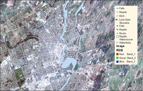
Data Source: Taken from Scholars GeoPortal on July 7, 2012. Data includes layers from the Ontario. Ministry of Natural Resources Ontario Hydro Network (2010); Imagery from the Ontario Ministry of Natural Resources - Digital Raster Acquisition Project East (DRAPE) imagery initiative (Groupe Alta) 2009; and the Open Street Map base map (2011).
For Assistance
For local assistance with Scholars GeoPortal, contact Trent University Library's Maps, Data & Government Information Centre - madgichelp@trentu.ca.